Nov10/25-lecture on The disappearance of MH 370… the last for a while

Its disappearance is the most significant aviation mystery since disappearance of Amelia Earheart 

It happened 11 years ago in March 8, 2014. There were 227 passengers and crew of 12 on board for a total of 239. It was a scheduled flight from Kuala Lumpur to Beijing, a 6 hour flight. 

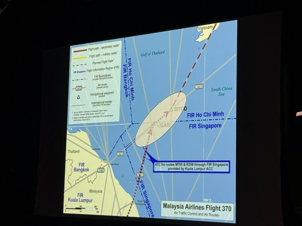
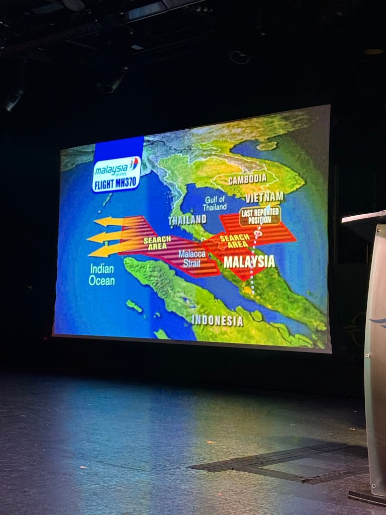
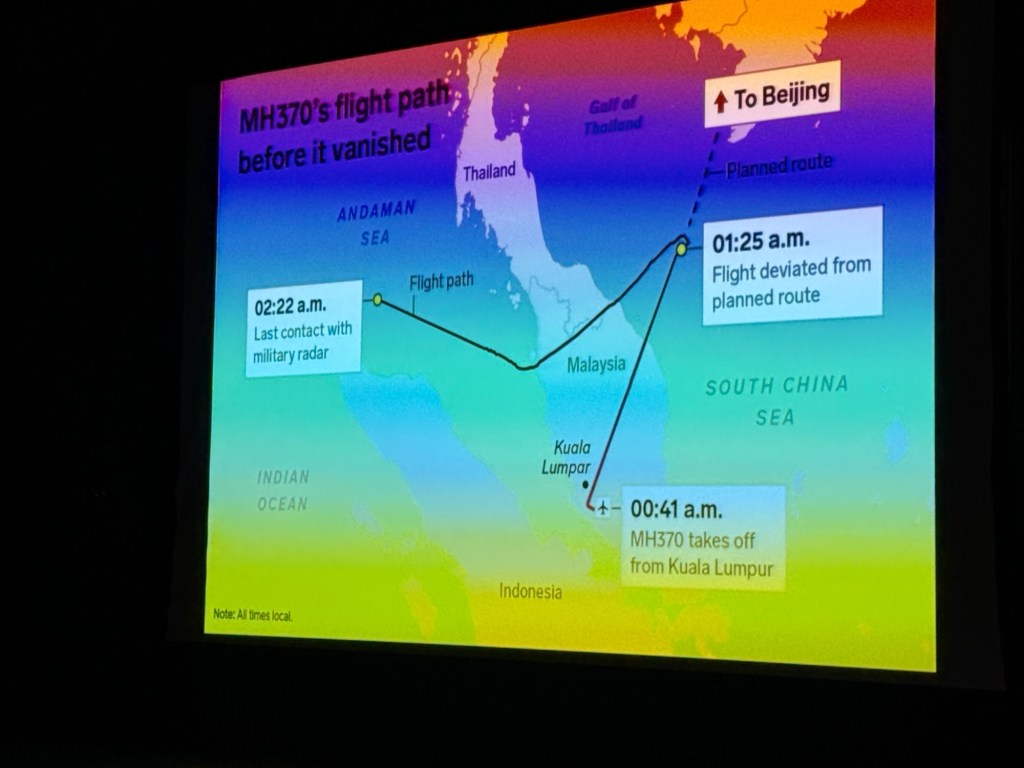
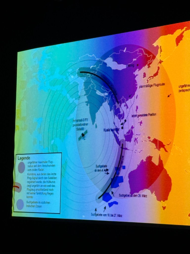
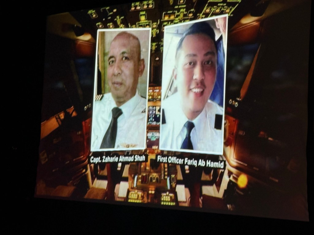
They were to fly in NE direction over Vietnam then pretty much over land in China. At weigh point IGARI…. Vietnamese air control was to take over from Malaysian air control. The captain said “Good night Malaysia” as it crosses into Vietnam control 40 minutes after departure. It disappears off the screen, no longer having any contact with anyone. Vietnam tried to contact plane. The plane had 8 hours of fuel on board. Searchers found nothing in the area that it disappeared. Nothing was seen by anyone. One possible thought was that the plane was downed by something in cargo. There was a large amount of lithium batteries in cargo.  Could it have been something to do with that??? Then they thought it might be cyber hijacking possibly, or a secret landing, the Bermuda Triangle… abduction by aliens???  International searchers found nothing including in the Indian Ocean. Malaysian official were surprisingly quiet….not very transparent which made others suspicious. Primary radar at the disappearance picked up that it went in different direction….a more complicated theory by Inmarsat mobile satellite company. Data suggested for 7 hours that it has been flying south and subsequently lost off the coast of Australia… an all-silent flight. The plane flew at oscillated altitudes. It had to have a human perpetrator??? The captain began to be suspect because he had marital problems, had a flight simulator at home with exact route on it and he had asked for extra oxygen in cockpit. The sharp turn at IGARI had to be done manually. It then crossed along the border between Malaysia and Thailand to Andaman Sea (where each country would think the other was aware of the airplane), then south for 7 hours until it crashed into the southern Indian Ocean off coast of Western Australia …after running out of fuel. 

The Ocean Infinity, a search ship checked the sea bed off Australia that is very deep & very mountainous…. 13,000 feet deep. 

In Jul 2015 piece of metal  debris (a flapperon… part of wing)  washed  ashore on the east coast of Africa. It was not damaged suggesting a controlled landing.…. 

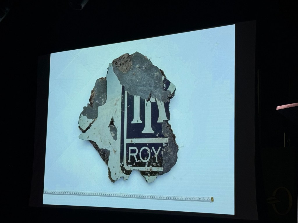
The presence of barnacles indicated the location off Australia. It could have coasted on the sea currents to its African location. 

The search is still on. 

Nov 9/25-Talk about “The Real Bridge over the River Kwai”

The movie was based on the fictional story by a French prisoner of war. It’s the story of the POWs sabotaging the building of the bridge.

It all started in Feb 1942 with the fall of Singapore. The Japanese goal was to take British India by going overland through Siam and Burma…250 miles through jungle, mountains and rivers. Japan needed manpower….  because they themselves were stretched thin. There were 140,000 of all different nationality POWs.  They had to build their own accommodation. Before that they had to walk to where they were to build the railroad/bridges, through  hot steamy jungle with mosquitos that caused dengue, malaria and dysentery was rampant. Their diet consisted of only 1/2 cup of rice or soup a day. They endured brutal treatment by Japanese and Korean soldiers. It took 60,000 allied prisoners of war to build plus 200,000 south Asian workers. No one tried to escape because of the thick jungle. They wouldn’t have a chance of survival. They felt that the only way to escape was to complete the railway. Only 4 workers worked together at a time….. one to chip away at the dirt or rock, one ti put it into containers and 2 to haul it away. The Japanese disregarded Geneva Convention on ethical treatment of prisoners. Elephants were also used and were also treated poorly, consequently dying. 1+ deaths of allies POWs plus many more SEAsians for each 2 sleepers. It was also called the Death Railway. There were over 100,000 deaths. The bridge was not blown up as in movie. The allies attempted to blow it up from air finally bombing 2 of spans of River Kwai bridge. The nuclear bombing of Japan brought about the release of ally POWs of as well as SE Asian POWs but many never recovered….. suffering from modern day PTSD. There is 80 miles in Thailand that remains even if the rest has been dismantled.  The bodies of those that died were never repatriated. 1 person died for each 2 sleepers. The British military was not happy with the movie because it implied that the British helped the Japanese. 

“The Narrow Road to Deep North….”is an Australia modern version of the story about the railway. 

Nov 8/25-Enrichment lecture on “In Search of the Spice Islands”

We actually met the speaker coming off the elevator when we were heading to the solo meet up. He also happened to be joining the group. His name James Grant-Peterkin. 

The Portuguese were the first of many to “discover” & colonize this area.  The Dutch influence in Indonesian (Melucecas islands) and French in Vietnam. This area had British influence but Thailand had never been ruled by Britain nor any other country. Mostly the explorers came because of trade…. silk, gold, spices, etc. Because of the expeditions there was also an exposure to & exchange of religions.  

The book Travels of Marco Polo, written in 1298, inspired exploration. Polo purposely didn’t tell all because he thought Europeans couldn’t accept all the knowledge he had acquired. 

The Straits of Melacca, a highly active route… is the key to international trade to this day. Spices that they were in search of  back in that era, was not just for flavour but to hide the taste and smell of rotting meat…. also for making perfume, creating wealth. Spices were used also in making health concoctions. Indonesian has 17,000 isles of which 

Moluccas, a group of Indonesian islands formerly known for their exclusive production of nutmeg, mace, and cloves. They opened the sea route on return to Asia by land, because of costs charged to go both directions.  Dias was first to find east route…. around the tip of Africa. Dias did not venture farther though but others did. 

Christopher Columbus used the writings of Marco Polo to find his way to the Americas in October 11/1492. He was actually searching for the East Indies. The people that he saw though didn’t look like the East Indies peoples he was expecting nor did they have the spices, etc. Amerigo Vespucci actually named Americas. Vasco de Gama found a route to India, Magellan, then Francis Drake circumnavigated world. 

Because of these attempts to find the best routes to the Spice Islands, the globe was explored. 

Nov 7/25- Ang Sila

Our guide’s name today is Phon. She says just call her IPhone 

We will be going to Ang Sila where they make mortar from stone and to make special sticky rice sweets

First we stop in a market where all kinds of sweets are made especially. And, all kinds of fresh fish…. all for sale. Khaolam… rice is soaked in water first for 30 minutes then coconut milk and salt, then stirred. Then black bean and taro are added….. and sugar. It is then put into bamboo only partly filled wrapped in banana leaves & burned for 2 minutes or in bamboo for 2 hours.  So many kinds of sweet treats made with sticky rice. 😋

Next is to Ang Sila 

Before arriving we were issued face masks because there is lots of dust at the mortar “factory”.  Basically it’s a granite quarry that they make figures of elephants, Buddhas, granite slabs (for countertops?) and mortar and pestles for grinding spices, etc. Pretty much all done with hammer and chisels. There is some final work done using a grinder.

We stop by the pier where you can see fishing weirs (poles) out in the water. They are farming mussels.

November 5/25-Floating market and Train Market 

Here we are sitting in Starbucks at Old Siam Plaza where we were to join the tour yesterday to Ayutthaya. This one is to the floating market and the train market. Got here in plenty of time today. Yesterday was a disaster getting to the meeting place. Our meeting place was to be Old Siam Playa…at 8:30 am.  If you have ever been to Bangkok and tried to get anywhere during the morning rush, you will know that the traffic is unbelievable obscene. The taxi driver couldn’t find how to get there, the traffic was horrendous. He couldn’t understand us and we couldn’t understand him. We ended up having to go to another meeting point cuz the bus had to leave. OMG!  He felt so bad that he refused to take payment even though it took almost 2 hours out of his time to make money. Getting to the pick up point was an experience unto itself. 

Damnoen Saduak floating market

Then to train market

I wanted to attach a couple of videos of the train coming down the track as well as the removing of merchandise off the track before it gets there but I don’t seem to be able to do it. If you want to see it you’ll have to visit me when I’m home.

November 4/25-Ayutthaya, former ancient capital

It is 80 kms to Ayutthaya from Bangkok. On the way out of the city we pass by the old railway station.  King Rama 5th brought trains to Bangkok 125 years ago…. in 1880.

Heavy rains that we experienced on Sunday when I arrived and last night, were from a typhoon.  It caused widespread flooding in the city.  The lightning last evening was so close and intense that made me just about have a heart attack. 

The new train station was built outside the downtown area, about 6 years ago but in another few years they with have high speed train to, starting with China & then to Europe.  

We arrive at the site at 10:25. There were 34 kings that reigned in Ayutthuya.

King #25 (of the 34 kings)built the stupas outside of the city in 1630. He dedicated it to his mother. It was built on land outside the city of Ayatthuya, that had been hers …..to celebrate his victory over Cambodia.  The surrounding area was for foreigners. Ayutthaya city is actually surrounded but 12 km of rivers (3rivers) …..only Thai personal/and military lived in the city area. 

There are 120 Buddha images. The Burmese later burned all the buildings. 

Golden Buddha in Bangkok, was made from rings & other jewelry belonging to the people as a way for them to contribute.  When it was made of solid gold, it was then covered with plaster. It, along with all statues of Buddha were transferred as much as 528 kms to Bangkok where it would be protected by the king of Thailand (a different set of kings from the ones that ruled Ayatthuya).  While being moved to the second floor of the building in Bangkok, it was dropped breaking the plaster and exposing the gold underneath. 

In the area outside Ayutthaya city, buildings or stupas were for the keeping of the ashes of royalty. One of the princes (how dare he)had affair with his father’s concubine. He was caned….beaten and died that day while the concubine, also beaten, died 3 days later. His “stupa” is the smallest of the buildings.  All of buildings were gold plated originally but are now only brick. Some are being reconstructed. 

In 1374, the temple in the “city” was built by 3rd king.  In the museum (that we didn’t stop at) is a room where the royal jewels were kept.

One temple, in 1911 was destroyed by earthquake.

We then stopped for lunch ….

Then to most important temple (within the city of Ayutthuya) from King #8. Treasures were kept in the temple/palace. It is a massive complex. There the Buddha was 343 kilo gold 16 metres high. Our guide pointed out the burial place of kings #8, 9, 10.  All the gold was taken by Burmese….palace/temples destroyed by fire in 1778.

Ayutthuya was the capital from 1350-1767.

Bangkok-November /25

I arrived here on the 2nd with nothing to report other than it was an awfully long couple of flights….just over 20 hours including a stopover in Hong Kong. Needless to say, I crashed very early evening. What a beautiful riverside resort we are staying it called the Anantara Riverside Resort.

Thailand is morning the passing of the Queen Mother for 90 days. Everywhere you see pictures of her. Some places were not open because of it. We were asked to not wear flashy bright clothes out of respect.

The Chao Phraya River literally snakes through Bangkok, is 370 kms long, continuing into the heart of the country.  It has been the centre of Thai life for centuries.

November 3/25 Our first excursion, to get our bearings in the humongous city, we did a hop on, hop off bus.

National barges, built in late 1800s can been seen at  the Royal Barges Museum. 

Si Lom Road meaning “turbine” road, is the financial, main business centre of Bangkok 

Patpong, an older well-known tourist entertainment district known for its night market and nightlife-after 6pm, for fun and entertainment …typically strip bars, pole dancing and prostitution.

We passed by the Jim Thompson silk shop someone had told me about but I never got off to explore.

Royal park was donated by king.

On Rachadamri road-Rachaprasong mall, has 600+ stores, huge shopping. It’s across from Grand Hyatt. 

Central World Mall. 

Samyan mitrown-mixed use area of residential and shopping has underground tunnel and train.

Golden Buddha is a rock solid gold statue (5.5 tons)had been covered by plaster, hidden from all for centuries, (probably built in the 15th century), until in an attempt to move it, was dropped exposing the solid gold underneath.

1896 first train built. Railway station built in 1910. 

Next is Chinatown 

In the past there was all kinds of restaurants and food shops, operas, brothels, gambling dens, all of which are no longer in existence except for food & restaurants.

132 gold shops

Next is hospital initially built for sick prostitutes but now is a regular hospital. 

Near Wat Intharawihan in 1820’s, so many died from cholera.  They couldn’t cremate the bodies fast enough so vultures ended up eating the remains, mak8ng them so fat they couldn’t fly. 

Next we drive through Khaosan road… is the “road of life”.  In 1892 tourism began there in Thailand with coach leaving from there.  It was also an

area where movies were made.   

Giant swing… no longer used

1807  wat pho temple… historical

Back to the west side of river  where our hotel is, originally was the capital of Thailand. Siam, until 1939, was the name of Thailand. 

City name in Thai is 169 letters long, the longest name in the world… means “City of Angels”.

Icon Siam, a huge shopping centre has 169 stores ……. is where we ended our tour today.

One of the things that leaves quite the impression on me is the amount a high rises …. that are spectacular in design. It sure would be good to see something “different” like these at home. I don’t know what kind of a job or business you need to have in order to rent one. A taxi driver said rent is 5 million baht per month …. About 21,000CAD. I don’t know how true that is.

Maybe my next post will be less “combobulated”.

More postings of Brown’s Bay

Don’t forget to click on the “gailstraveladventures.net to take you to the website, then click on one of the pictures and then all will enlarge.

The follow are views of the Coast Mountains returning from Cortes Island

I was a little delayed in posting. Sorry! The push was on me to get them done before embarking on another trip.

Vancouver Island places that I have explored this summer 2025

Amazing Parksville Sand Castle Competition Aug. 4/25. These are some but not all of the displays. You have to enlarge the pictures to get the detail that went into the sculptures. To do that click on “gailstraveladventures.net” that is in the email, to take you to the website. From there you should be able to click on the pictures to make them big.

Visit to Hand of Man in Maple Bay, an amazing museum of artifacts and stuffed animals Aug. 3/25

Brown’s Bay Resort August 22-September 5/25

This is predominately an RV Park on the waters of Seymour Narrows. It is just north of the site of Ripple Rock where the world’s largest non-nuclear explosion happened in 1958. Because of that explosion and consequently the elimination of the major hazard to navigation, there are many ships of all different size and purposes, that travel up and down the coast using this route. Below are some of the ships that we saw pass through. Also included are scenes in the park including some very cool wood carvings. Besides being a RV park, it also has deep water docks and a very good restaurant (as well as a fish plant).

The drive in is on an old logging road. On the drive, probably because it is a little rough, there are signs saying how far to go.

In between we drove up to Telegraph Cove to see the damage and progress that has been made since the fire that destroyed a part of the boardwalk, cafe and pub and the Prince of Whales offices and museum as well as a couple of houses, on New Year’s Eve 2024.

I will send some more sights from Brown’s Bay in another posting. I believe I have overloaded this one so it is being difficult.

Western Canada Road Trip-June 25-July16/25.

This was a trip not to see the sights so much but to visit with friends and family. In some cases, I hadn’t seen in years.  It was filled with wonderful visits and guess what, I saw some incredible sights (sites), too. Personally, I recommend that you enlarge the pictures to really see the beauty of our country.

First, lucky me, I drove right on the ferry without booking a reservation, even though I left home later than I was planning on.  (One thing I resent is having to pay for a reservation. The ferries are part of the highway system).

First stop was Chilliwack (25th), then up the Fraser Canyon to Kamloops (26th and 27th)

Then to Prince George (28th,  29th and 30th).  Along the way between Kamloops and Pr. George, I had a visit from an RCMP officer…..Oops!

From there it was driving on Hwy 16 to Jasper, then hwy 93 and the Columbia Icefields, turning at the Saskatchewan River Crossing onto Hwy 40 to Lacombe, Alberta. 

Next, I spent a few days (July 1-4) visiting a friend in Lacombe and doing a little exploring.

Next it was driving through lots and lots more florescent yellow fields of canola on the flat prairie highways of Alberta and Saskatchewan.  I stopped at the airport in Saskatoon to pick up a friend coming from Victoria.  Together we travelled to see our friends that live in Prince Albert, Candle Lake and Waskesui Lake. We had first met them in Guayabitos, Mexico.  For a time it looked like we wouldn’t be travelling to those northern reaches because of forest fires but they managed to get them under control .  So much of our country has had wildfires, each year it seems, getting worse and worse.  We did experience some smoke but it was not too bad.  One thing I was expecting was that temperatures would be stinking hot.  Because of the smoke in the air, even though low, helped to keep the temperatures down.  We spent July 5-10 in Saskatchewan then I travelled back to Alberta  on the 11th, this time to visit friends in Red Deer.

I spent July 11-13 in Red Deer with friends, then to Carstairs (July 14) to visit another but with a detour down to the badlands of Drumheller and the amazing Tyrrell Museum of Dinosaurs. I had never been before so needed to go.

Next day (July 15th) I drove on through the Rockies again (Hwy 1), this time through Banff, Yoho National Park and Rogers Pass to Kamloops. 

July 16th I left Kamloops on Hwy 5 (the Coquihalla), dropping off to see a friend to pick up the jacket I left behind in Chilliwack.  Then it was onto the ferry (again no reservation and driving right on….yeah, and home.